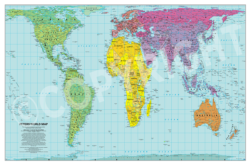
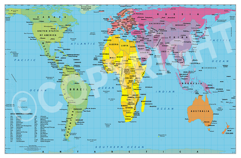

The Peters World Map is an Equal Area cylindrical projection with standard parallels at 45 degrees thus resulting in a distortion of shape which is stretched about the equator and squashed towards the poles, but having the great advantage that all countries are correct in size in relation to each other. Widely used in educational and business circles as an icon of the modern concept of world equality.
Lastest updates: Peters World Maps last updated October 2024.
Overview
The Peters Project Map, also known as the Gall-Peters projection, is a world map projection designed to offer a more accurate representation of the sizes of landmasses. Named after historian Arno Peters, who popularized it in the 1970s, the Peters projection is based on a cylindrical equal-area map created by James Gall in 1855. Its aim is to provide a more equitable perspective by showing all regions of the world in their correct proportional sizes, addressing the distortions present in other projections, like the Mercator projection.
Why the Peters Map Matters
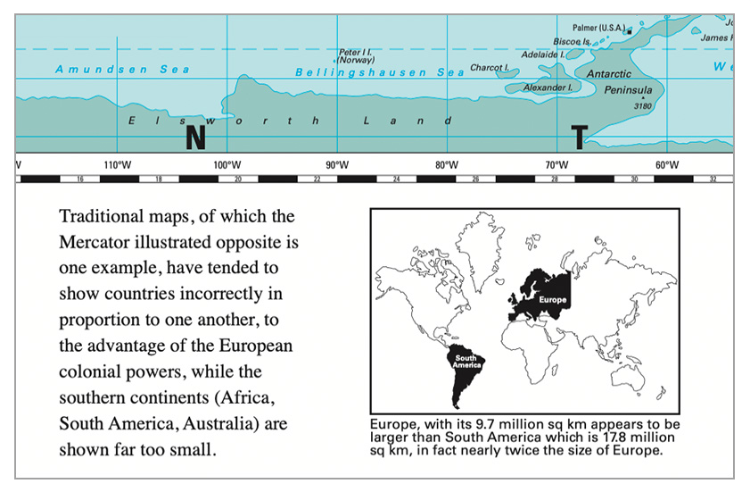
Traditional world maps, particularly the Mercator projection, have often distorted the relative sizes of countries, making regions closer to the poles appear disproportionately larger than those near the equator. This has led to perceptions of importance or dominance of certain areas over others. The Peters Map challenges these views by depicting each country in a way that accurately reflects its actual size in relation to others. This has profound implications for understanding global equality, resources, and cultural perspectives.
Features of the Peters Map
Equal-Area Projection
Every area on the map is proportionally accurate, making it an "equal-area" map. This means that the landmasses are displayed in correct sizes relative to each other
Equal Axis
All North-South lines run vertically on this map. Thus, geographic points can be seen in their correct geographical relationship – northwest, northeast, southwest or southeast.
Equal Positions
All East-West lines run parallel. Thus the relationship of any point on the map to its distance from the Equator or to the angle of the sun can easily be determined.
Distortion of Shapes
Unlike the Mercator projection, which preserves shape, the Peters projection distorts the shapes of countries, especially near the equator. This is a trade-off for size accuracy.
Representation of Global South
Countries in the Global South, such as those in Africa, South America, and parts of Asia, are more accurately represented in terms of size. This counters the traditionally larger depictions of Europe and North America.
Fairness To All Peoples
This map presents all countries in their true size and location, accurately reflecting their actual positions in the world.
History and Development
The original concept for an equal-area projection similar to the Peters map was created by James Gall in 1855. However, it wasn’t until the 1970s that Arno Peters brought it to international attention, framing it as a political statement against imperialist influences in cartography. By choosing to display all nations accurately by size, the Peters projection provides an alternative to the Eurocentric Mercator projection, promoting a more inclusive worldview.
The Peters Map, also known as the Gall-Peters projection, is a world map projection developed by German historian and cartographer Arno Peters in 1973. The projection aimed to provide a more equitable view of the world's landmasses by representing countries in sizes that correspond more accurately to their real geographical areas. Unlike the commonly used Mercator projection, which distorts the size of countries as they move further from the equator, the Peters projection attempts to present a "fairer" view by using an equal-area projection.
The Peters projection is based on a cylindrical equal-area design first proposed by Scottish clergyman James Gall in the 19th century. However, Gall’s design did not receive significant attention until Peters revisited and promoted it as a counterpoint to the Mercator map, which he argued privileged the Global North over the Global South by exaggerating the size of regions like North America and Europe while shrinking Africa and South America. By emphasizing the actual proportions of land areas, Peters aimed to promote a more balanced worldview and to support social justice initiatives, especially in the context of the Cold War and decolonization.
The map gained popularity in academic and social justice circles, and several organizations adopted it to support global education and equity efforts. However, it also generated substantial controversy and debate among cartographers and geographers. Critics argued that while the Peters projection corrected some size discrepancies, it introduced significant shape distortions, elongating countries near the equator and making continents appear stretched vertically. Traditionalists pointed out that no single projection can represent the three-dimensional Earth on a two-dimensional plane without some form of distortion, as each map has to balance trade-offs among shape, size, distance, and direction.
Despite these criticisms, the Peters Map has remained influential in discussions about how maps shape perceptions of the world. By challenging the Eurocentric view prevalent in many map designs, the Peters projection has prompted greater awareness of the political and social implications of cartography.
Use of the Peters Map Today
Today, the Peters projection is often used by organizations and educators advocating for a more just and equitable view of the world. It’s popular in classrooms, non-profits, and institutions focused on global awareness. Although it’s not universally accepted as a standard, its influence on discussions of map projection and cultural representation remains strong.
Licensing the Map
As well as the print options listed on the Etsy site, if you want the maps in different format, we are able to offer different options:
- Material (paper types)
- Finishes (matt/satin/gloss)
- Lamination
- Encapsulation
- Framed
Contact us to discuss
Licensing
Should you wish to license the maps to be included in your publications or become a distributor, again, please contact us to discuss options.